
Tuesday, November 25, 2008
Sunday, November 23, 2008

Saturday, November 22, 2008
Working with Styles assignment.
I used the kuler.adobe site to create compatible colors for symbols on this map of Buncombe County, and as a starting point for color ramps for elevation and hillshade. I found that the colors didn't look quite the same in ArcMap as they did in Kuler, so ended up tweaking them a lot.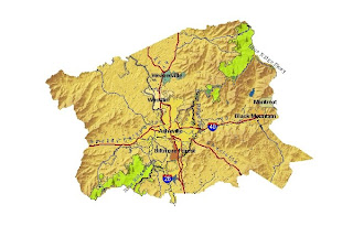
I used the kuler.adobe site to create compatible colors for symbols on this map of Buncombe County, and as a starting point for color ramps for elevation and hillshade. I found that the colors didn't look quite the same in ArcMap as they did in Kuler, so ended up tweaking them a lot.

Subscribe to:
Posts (Atom)